Michigan residents are worried about a spill of the Line 5 underwater oil pipeline in to the Straits of Mackinac and are even more concerned about a rupture during winter’s icy conditions, new Michigan State University research finds.
Sixty percent of Michigan adults questioned last fall indicated that they were aware of Line 5 that carries 540,000 barrels per day of light crude oil and liquid natural gas beneath the Straits of Mackinac.
Of those familiar with the pipeline, 44 percent were extremely concerned about a spill. Only six percent reported no concern in questions asked in MSU’s State of the State Survey, said Doug Bessette, assistant professor in MSU’s Department of Community Sustainability.
The survey was the first to uncover what Michigan residents think about a pipeline spill occurring during icy conditions beneath the Straits. 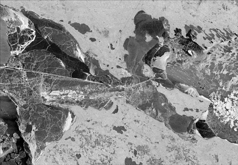 The waterway flows under the Mackinac Bridge and connects Lake Michigan to Lake Huron.
Paired with field work, this groundbreaking research is designed to gather information and examine new strategies to address cleanup of oil spills from ice-covered lakes water.
“We really wanted to understand what Michigan residents understood about Line 5, especially during icy conditions,” said Grant Gunn, principal investigator for the interdisciplinary research team combining survey, focus group, satellite and onsite measures.
“We also want to know how residents and decisionmakers perceive Line 5’s risks,” said Bessette, a member of the research team. “We also want to know how decisionmakers and policymakers can better address these risks.”
The research is supported through IPPSR’s Michigan Applied Public Policy Research grant linking faculty research to current policy debate. In MSU’s College of Social Science, IPPSR is known for its policy education, political leadership training and survey research.
The work was released during IPPSR’s State of the State Podcast, debating current affairs and showcasing faculty research.
The survey research was based on 955 cellular and landline calls to Michigan residents. It carries a margin of error of 3.17 percent.
In other survey findings, of those responding that they were aware of the Line 5 pipeline:
- Forty-two percent were more concerned about an oil spill when the waters are covered with ice than were concerned about spills during times of open water.
- 47 percent reported the economic benefit of Line 5 wasn’t worth the environmental risk.
- 25 percent said Line 5 should be permanently shut down and not replaced. Another 14 percent said it should be left in place. Fifty-two percent reported that Line 5 should be shut down and replaced.
About 36 percent of those responding to the survey said they weren’t aware of the 645-mile pipeline that crosses the U.S. in Superior, Wisc. and heads south under the Straits before terminating in Sarnia in Ontario, Canada.
More Democrats, about 47 percent, than Republicans, 5 percent, supported the pipeline’s permanent shutdown. A majority of both parties said the line should be shut down and replaced: 51 percent of Democrats and 65 percent of Republicans.
The state and Line 5 owner Enbridge LLC of Alberta, Canada, have announced an agreement to replace the pipeline.
The research team’s next goal will be to travel to the waterway that divides Michigan’s upper and lower peninsulas to determine how oil behaves when mixed with ice during freezing winter conditions, Gunn said.
“We know more about how oil is dispersed during good weather,” he said “We know less about oil and ice.” Powerful Straits’ currents, combined with ice’s natural rough texture, may restrict oil’s spread, he said, or oil may emulsify and travel.
The team hopes to seek an expanded grant to explore the national ramifications of oil and ice’s mix during Arctic or offshore drilling, as well as how the public perceives those risks, Bessette said.
The image above is is a radar image of the Straits of Mackinac. Taken on February 9, 2019, it shows the region entirely ice covered, with variations in light and dark tones representing variations in ice types, roughness, and cracks/leads of ice pans. This type of imagery will be used in analysis of the potential to observe and track oil spills using remotely sensed observations.